Thursday, April 17, 2014

Climate Change Impacts and Mitigation

The continent of Africa is expected to have a climate shift towards generally drier and warmer weather caused by the changing sea surface temperature. Warmer SST in the Indian Ocean has been linked to an increase in stable inversion layers in the atmosphere over the course of a year. Clouds struggle to form in a stable atmosphere because air is generally sinking, and cannot form at all in an inversion layer, which would be responsible for a decrease in rainfall over time. Large regions with little variability in climate such as the Sahel provide very little data for scientists to make an accurate prediction on future climate change in these areas. The climate in areas near the Inter-Tropical Convergence Zone (the southern coast of Africa) are also troublesome for scientists to predict because the ITCZ isn't always where the scientists predict it's going to be, yet they use their predicted data to estimate future climate change, which is inaccurate.

The continent of Africa is prone to climate change in the near future, yet it is a very poor continent with very little resources to adapt and help it's people deal with hardships. Many African people do not have a clean, reliable water source and by 2020, it is estimated that this problem will skyrocket into the hundreds of millions of people taking into account for the increasing population. As for food, agricultural production is expected to drop because of decreasing rainfall in the future climate, which decreases the amount of food available on an already starving continent. Africa will drain resource after resource until it has nothing left and is uninhabitable.

To put it simply, Africa is a region still trying to recover from many past events that left scarring impacts on almost every aspect of African society. This is not a region that is not ready to take on severe climate change because of the fact that Africa can barely, if even rely on its own resources to support it's people. Climate change can further hamper these resources that are already being depleted, which will inhibit and reverse efforts to make Africa the least bit self-sustainable. Lack of resources is the reason for illness and disease, and with the shrinking amount of inhabitable land, disease will spread quick and run rampant among the population, killing many African people.

The most interesting threat for Africa due to predicted future climate change is the increase in water stress for the people of Africa. Africa as it stands today is suffering from a severe drinking water shortage for their booming population. With the future climate change expecting to decrease rainfall, Africa will have even less available drinking water to distribute amongst and increasing amount of people. Water stress also relates to agriculture, as most of Africa's economy comes from agriculture, and is directly related to the amount of food available to the African people. With decreasing rainfall, crops will begin to die and areas once suitable for agriculture will become barren, and the people of Africa will starve even worse than they are now, if that's even possible.

map from http://www.mappery.com


courtesy of https://globalizationstudies.sas.upenn.edu

Friday, April 11, 2014

Severe Weather in Zimbabwe

Tornadoes are a type of severe weather that forms in a very unique fashion. The formation of tornadoes always occurs during a thunderstorms, during permitting conditions. Because of increasing wind speeds at higher altitudes and drag and friction caused by the surface (vertical wind sheer), a rotating body of air known as a vortex tube forms along the surface of earth. This horizontal column of air is lifted up and vertically by the warm updrafts of a thunderstorm and a "mesocyclone" forms. When this mesocyclone is fully developed in the updraft of a thunderstorm, it is now a tornado. Tornados in the United States travel in a northeast direction because this is the direction of the prevailing westerlies that affect most of the continental US. Very rarely do tornadoes occur in Zimbabwe because of it's unique location and how it is being shielded by Madagascar from the direct path of the NE trades. The average number of tornadoes that occur yearly in the US is 1253 (http://www.ncdc.noaa.gov/climate-information/extreme-events/us-tornado-climatology). The average number of tornadoes that occur yearly in Zimbabwe is hard to find, most likely because there is not a very high chance of running into a tornado in Zimbabwe.

http://www.ncdc.noaa.gov/img/climate/research/tornado/globdist.jpg

Although Zimbabwe is very close to a tornado hotspot over South Africa, it avoids these tornados and steers clear of this 'hotspot" because of Madagascar off the coast of Africa and how it blocks and diverts the prevailing wind direction, which would be where most of the tornados are coming from.Though tornado occurrences appeared to have increased over time, this may not be entirely true  because in the last 30 years, the methods that have developed in detecting and accounting for tornadoes have greatly improved. Because of this instead of the number of tornado occurrences going up, maybe it's just the number of tornadoes able to be detected has risen.

The three main requirements for a hurricane is : 1) warm ocean temperatures, at least 80 degrees fahrenheit or higher, 2) deep warm ocean layer (200 m deep, only occurs <20 degrees latitude) and 3) Coriolis effect to start the rotation (needs to occur within 5 degrees latitude of the equator). The three regions in which hurricanes occur is: 1) in the Atlantic and East Pacific (called hurricanes) 2) in the Indian Ocean near Australia (called cyclones) 3) off the coast of China and Indonesia (called typhoons).


http://spaceplace.nasa.gov/hurricanes/en/cyclone_map_large.en.gif

The general direction of Hurricanes in the US is normally in an eastern direction following the westerlies, though usually the hurricane starts off moving in a western direction because this is the direction of the trade winds where the hurricane originated. The general path of the hurricane follows the directions of the prevailing winds in the area. From it's place of origin up until the continental US, the wind direction completely flips, which gives hurricanes the appearance of changing directions. Again, hurricanes do not occur often or at all in Zimbabwe because of it's special location behind Madagascar, being shielded from the general direction of the wind and the path of the hurricanes. On the other hand, the United States averages 5.8 hurricanes per year, according to NOAA.

Thursday, March 20, 2014

Daily Weather in Zimbabwe

The capital of Zimbabwe is Harare, located in NE Zimbabwe at the elevation of 1490 meters. My 5 day forecast will cover the days of March 20, 21, 22, 23, and 24. The forecasted high (temperature) on March 20th is 86 degrees, and the forecasted low is 61 degrees. There is a 10% chance of precipitation as well. On March 21st, the forecasted high is 81 degrees, and the forecasted low is 60 degrees. On the 21st there is a 20% chance of precipitation. The next day, March 22nd, has a forecasted high of 77 degrees and a forecasted low of 58 degrees. The 22nd has a 40% chance of precipitation. March 23rd has a forecasted high of 81 degrees and a forecasted low of 56 degrees. There also is a 10% chance of precipitation on this day. Finally, March 24th has a forecasted high of 82 degrees and a forecasted low of 59 degrees. There is a high chance of precipitation on this day at 60%.


image courtesy of wunderground.com

As you can see from the satellite image, most of the clouds surrounding Harare are cold clouds. These clouds develop higher in the atmosphere and is responsible for most of the precipitation over Harare. The low elevation warm clouds signified by the grey areas are very sparse and have less effect on daily weather than the vast cold clouds hovering over it. The higher elevation clouds form because of the high elevation that Harare lies at, and orographic lifting pushes the air further up past where clouds would normally form in the atmosphere. Though Zimbabwe is landlocked, Harare is close to Lake Manyame, about 30km east. The type of clouds that form over the lake are low-lying warm clouds.

image from intellicast.com

This is a surface pressure map of South Africa. There is a high pressure system covering most of the region in this map, with the center right on the coast of the south tip of Africa. The isobar pressures observed are 1020 millibars (mb) at the center of the high, 1016 mb and 1012 mb as we move further away from the center. Because the isobars are spaced out, the pressure gradient isn't very high so the winds aren't very strong. There is a stationary front of the eastern coast of Africa, but it isn't affecting the weather very much over land.

image from intellicast.com

Over the continent of Africa, there is a low pressure system forming in the Northwestern region, though there aren't very many low pressure readings on the surface analysis map. There are two high pressure systems affecting Africa, one directly north of the continent, and the other on the southern border of the continent. Both high pressure systems have a center pressure reading of 1020 mb, with readings of 1016 mb, 1012 mb, and 1008 mb all spaced far apart. This signifies a low pressure gradient over a large distance, which means the wind isn't very strong in the entire region. The only front close to the African continent is a stationary front off the southeastern coast of Africa. 


Thursday, March 13, 2014

Global and Local Winds in Zimbabwe

Zimbabwe is a African country at coordinates 19.0167 degrees south latitude, 30.0167 degrees east longitude. This puts Zimbabwe in the Southern Hemisphere, well within the tropics (from 23.5 degrees south to 23.5 degrees north latitude). According to the three cell model of global circulation discussed in lecture, Zimbabwe lies within the Hadley cell of atmospheric circulation (from 0-30 degrees north or south latitude). The Hadley cell consists of rising warm air at the equator cooling and moving towards 30 degrees N or S latitude where the air sinks and moves back towards the equator. The pressure gradient force is towards the equator from the location of the sinking air at 30 degrees S. In the southern hemisphere, the Coriolis Effect curves wind to the left, and friction in the opposite direction of the PGR curves the wind back towards the PGF. This explains the direction of the trade winds, which is the wind belt that Zimbabwe resides in. Though the trades blow east to west, the prevailing wind direction in Zimbabwe is hardly defined due to the location of Madagascar off the coast of Eastern Africa and how drastically it influences wind direction. Zimbabwe is located in the ITCZ, or Intertropical Convergence Zone, which is a main low pressure system that varies in latitude depending on the time of year. January is when Zimbabwe lies within the ITCZ, and is subsequently right in the middle of Zimbabwe's rainy season. Because Zimbabwe is within the ITCZ in January, it is also within the doldrums during this time. Doldrums are where the northern and southern trade winds meet at the equator  and creates an area of highly variable weather.

image from http://www.weatherwizkids.com/globalcirculation.gif

Zimbabwe's climate is directly affected by global wind patterns and pressure systems relevant to it's location. Zimbabwe's location at 19 degrees S puts it in the Hadley cell, which means wind is generally moving from east to west. This means that future weather can be predicted by looking at what type of pressure systems are developing over the Indian Ocean being that the wind is most likely going to blow this weather westward. Also Zimbabwe is very characteristic of tropical countries in that it has a distinct wet and dry seasons. This is due to the ITCZ shifting throughout the year and in January is when Zimbabwe lies within the ITCZ. In past years when the ITCZ wasn't very well defined, Zimbabwe experienced drought-like climate, and in past years when the ITCZ was very well defined, Zimbabwe receives average to higher than average rainfall. The rainy season occurs when the ITCZ approaches and reaches Zimbabwe, and the rest of the year receives essentially zero rainfall. This makes it easy to predict the weather of Zimbabwe during any time of the year.

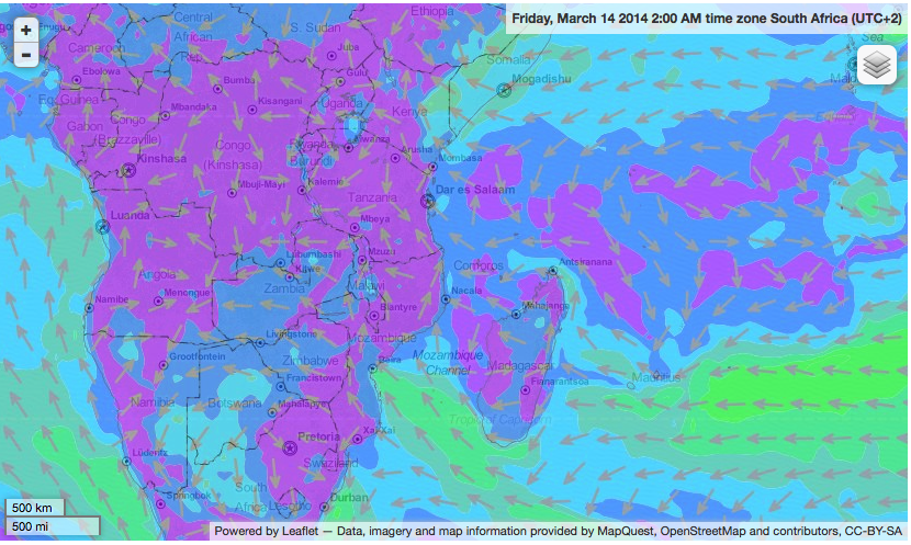
Zimbabwe has many mountains, from the Bvumba Mountains to the Eastern Highlands. The 5 types of breezes associated with mountains is the Chinook Winds, Santa Ana Winds, Katabatic Winds, Valley breezes and mountain breezes. Most of Zimbabwe's higher-elevation terrain is located on the eastern side of the country, though it has a minor effect of the wind direction because of the location of Madagascar, and how Madagascar actually is the main contributor to the unique winds in Zimbabwe. Because the trade winds blow from east to west and Madagascar lies east of Zimbabwe, the trade winds' path is blocked and deviated around the island, resulting in a northwestern prevailing wind direction. Madagascar also acts as a barrier to severe weather systems heading directly towards Mainland Africa, weakening and deviating it's path which lowers the instances of weather related disasters.

image from http://www.windfinder.com/weather-maps/forecast/zimbabwe#4/-12.38/41.31

Because Zimbabwe is landlocked, it is not directly affected by coastline breezes, such as land and sea breezes. The closest body of water is the Mozambique Channel, almost 500 miles away.


Thursday, February 27, 2014

Typical Weather and Tourism in Zimbabwe

Because Zimbabwe lays in the Southern Hemisphere, it's seasons are opposite of those countries in the Northern Hemisphere. For example, Zimbabwe experiences it's hottest weather from September to January and it's coldest weather from April to July. In contrast, The United States experiences it's hottest weather from June through September and it's coldest weather from December to February. This is important to know if one ever plans on visiting Zimbabwe, and can help decide on the appropriate clothing to bring and typical weather to expect. Knowing about Zimbabwe's rainy season (from November to March) is important as well because most activities take place outdoors, and heavy rain can ruin a day full of plans.

In 2014, the day of the winter solstice in the Southern Hemisphere is  June 21st. During June, the average maximum temperature in Zimbabwe is 71.4 degrees fahrenheit and the average minimum temperature is 45.6 degrees. During this month, rain is the type of precipitation most likely to occur, due to the average minimum temperature being well above freezing. Because Zimbabwe exhibits monsoon-like rain patterns, June would be a dry month and a great time to visit.

In 2014, the day of the summer solstice in the Southern Hemisphere is December 21st. During December, the average maximum temperature in Zimbabwe is 81.2 degrees fahrenheit and the average minimum temperature is 62.6 degrees. Excluding extreme circumstances, the only type of precipitation in Zimbabwe during December is rain. December is in the middle of Zimbabwe's rainy season, in which the country receives most of it's rainfall.

In 2014, the day of the spring equinox in the Southern Hemisphere is September 23rd. During September, the average maximum temperature in Zimbabwe is 81.6 degrees fahrenheit and the average minimum temperature is 54.5 degrees. Average minimum temperatures are well above freezing so rain is the type of precipitation most likely to occur. September is on the borderline of the rainy season, so rain should be expected when traveling to Zimbabwe during this time.

In 2014, the day of the autumn equinox in the Southern Hemisphere is March 20th. During March, the average maximum temperature in Zimbabwe is 80.4 degrees fahrenheit and the minimum average temperature is 60.7 degrees. According to these temperatures, rain the the most common type of precipitation during March. Zimbabwe's latitude puts in the tropics, and due to the constant warmer temperatures closer to the equator, any type of precipitation besides rain is very uncommon.

According the the weather data gathered above, the best season to visit Zimbabwe would be during the winter months, from June to August. Because Zimbabwe does have a rainy season, one wants to avoid this time entirely and visit when the weather is reliably sunny, so there are many activities one can partake in. Popular activities in Zimbabwe are sightseeing and freshwater fishing. There are many national parks with tour guides year-around, and many of the animals and plants are unique to those regions in Africa. Popular national parks are Victoria Falls National Park, located on the western tip of Zimbabwe, and Hwange National Park, about an hour south of Victoria Falls. These National Parks provide beautiful landscapes, breathtaking natural phenomenon, and a safe place for large wild animals  to inhabit. Lake Kariba lays on the northern border of Zimbabwe, and is the site of great freshwater fishing and fishing tours. Of course, fishing and sightseeing usually requires dry weather, so avoiding Zimbabwe's rainy season would be best.

There is very little potential weather hazards during winter season in Zimbabwe, as most of the extreme weather occurs during the exact opposite time of the year. Despite this, one can never fully predict weather, and should still be prepared for potential weather hazards. Zimbabwe is landlocked, so rain in large quantities are usually the cause of weather hazards. Flooding of rivers are the most common weather hazards, as well as sinkholes dues to extended periods of heavy rain. Because all of these weather hazards are caused by constant heavy rain, there is very little chance of weather hazards being a factor during a visit in the winter time. If one is looking to entirely avoid rain and a humid, hotter environment, Zimbabwe provides a perfect time of year to visit and have fun.

Devil's Pool in Victoria Falls National Park, Zimbabwe 
(http://www.justmegawatt.com/images/imageassets/odd/devilspool/victoriafalls.jpg)

If excitement and adventure is stuck on your mind, visit Zimbabwe and have an unforgettable time.


Thursday, February 20, 2014

Temperature Controls in the city of Harare in Zimbabwe

When most people are asked to envision the climate in Africa, they think of unbearably hot and muggy weather year around. This is not the case in the capital city of Harare, located in Zimbabwe. Though Harare's location lies in a humid subtropical climate zone, Harare also sits at an elevation of 1480 meters. Harare's climate is greatly attributed to its altitude, which moderates its climate and provides cooler, drier weather than the areas surrounding it.

Harare is the capital of Zimbabwe, and it lies at 17.86 degrees south latitude and 31.02 degrees east longitude. Because Harare lies in the southern hemisphere, it's winter months are the opposite of North America, occurring from June through August. The coldest month in Harare is July with an average monthly temperature of 56 degrees fahrenheit. Summer months in Harare are November through January, and are also the hottest months in Harare with an average monthly temperature of 70 degrees fahrenheit. According to this data, Harare has an annual temperature range of 14 degrees fahrenheit, which indicates that Harare has very little temperature change through seasons. Harare's latitude puts it in the tropics, between the equator and the tropic of capricorn. This accounts for Harare's mild seasonality, but it's moderately cool temperature is attributed to it's high elevation.
(http://www.harare.climatemps.com/)

Zimbabwe's geographic location puts Harare at an elevation of 1480 meters, almost a mile high. Altitude is one of the temperature controls we discussed in class, and is the main contributor to Harare's slightly uncharacteristic climate for the area. We learned that air temperature is controlled by solar radiation from the sun bumping into air particles, transferring heat energy from one particle to another. In higher elevations, less pressure is exerted on the atmosphere because it is further from earth's gravitational pull, therefore air is less dense at higher altitudes. Less air particles means the particles are further apart, and less collisions with solar radiation and other air particles. This means that less heat energy is transferred from the sun to the atmosphere, which in turn causes the temperature to be lower than it normally would at sea level.

A temperature control that wouldn't apply to Harare would be ocean currents. Zimbabwe is a landlocked country and therefore is not affected by any major ocean currents. There is an apparent south-easterly airflow cooling the city, but the winds affect the ocean currents, not vice versa. Ocean currents usually moderates climate, but in the tropics, climate is generally moderate already, so the effect is to a lesser extent.

According to current climate data, I would predict Harare's average annual temperature to rise in the future. I have come to this conclusion based on a few assumptions. First, I assumed that over time erosion takes place. Second, although not an accurate assumption, I assumed that erosion won't drastically affect ocean currents. Third, I assumed this climate change would take place before plate tectonics make a difference. Erosion would reduce the elevation of Harare, which would cause a rise in temperature. Also, erosion over time may bring the coastline closer to Zimbabwe, exposing Harare to the Agulhas current, which is a warm water current moving down the eastern coast of Africa. This would also cause the temperature to rise.

After looking into the climate of Harare in Zimbabwe, it is easy to see how temperature controls we discussed in class can directly affect climate of a region. Altitude is the main temperature control affecting climate in Harare, providing cooler annual temperatures than surrounding areas. Conversely, a temperature control such as ocean currents do not affect landlocked countries like Zimbabwe.