image from http://www.weatherwizkids.com/globalcirculation.gif
Zimbabwe's climate is directly affected by global wind patterns and pressure systems relevant to it's location. Zimbabwe's location at 19 degrees S puts it in the Hadley cell, which means wind is generally moving from east to west. This means that future weather can be predicted by looking at what type of pressure systems are developing over the Indian Ocean being that the wind is most likely going to blow this weather westward. Also Zimbabwe is very characteristic of tropical countries in that it has a distinct wet and dry seasons. This is due to the ITCZ shifting throughout the year and in January is when Zimbabwe lies within the ITCZ. In past years when the ITCZ wasn't very well defined, Zimbabwe experienced drought-like climate, and in past years when the ITCZ was very well defined, Zimbabwe receives average to higher than average rainfall. The rainy season occurs when the ITCZ approaches and reaches Zimbabwe, and the rest of the year receives essentially zero rainfall. This makes it easy to predict the weather of Zimbabwe during any time of the year.
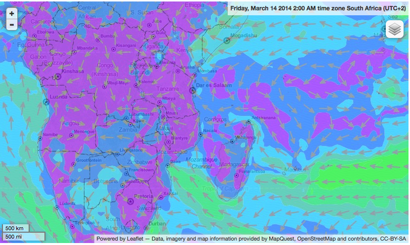
Zimbabwe has many mountains, from the Bvumba Mountains to the Eastern Highlands. The 5 types of breezes associated with mountains is the Chinook Winds, Santa Ana Winds, Katabatic Winds, Valley breezes and mountain breezes. Most of Zimbabwe's higher-elevation terrain is located on the eastern side of the country, though it has a minor effect of the wind direction because of the location of Madagascar, and how Madagascar actually is the main contributor to the unique winds in Zimbabwe. Because the trade winds blow from east to west and Madagascar lies east of Zimbabwe, the trade winds' path is blocked and deviated around the island, resulting in a northwestern prevailing wind direction. Madagascar also acts as a barrier to severe weather systems heading directly towards Mainland Africa, weakening and deviating it's path which lowers the instances of weather related disasters.
image from http://www.windfinder.com/weather-maps/forecast/zimbabwe#4/-12.38/41.31
Because Zimbabwe is landlocked, it is not directly affected by coastline breezes, such as land and sea breezes. The closest body of water is the Mozambique Channel, almost 500 miles away.

I am actually kinda surprised at all the carious types of winds that Zimbabwe has when compared to Bangladesh. I mean geographically, they are relatively close to each other, kinda (even though you're country is in the south and I in the north) and they are both in Hadley cells in the Tropics. I guess the Horse Latitudes that affect where Bangladesh is located really creates all the difference. Haha, the Horse Latitudes kills weather, while the doldrums create it. Also you have mountains to give you wind where as Bangladesh is mountain-less. The only way for Bangladesh to get wind is by land and sea breeze, which also brings the monsoon that floods like 65% of its land.
ReplyDeleteEven though El Salvador and Zimbabwe are in different hemispheres they are both in the Hadley cell and are effected by trade winds. They both also have mountains that give them breezes but El Savlador is also on the coast which gives it sea and land breezes whereas Zimbabwe is surrounded by land. Its cool that even though our countries are no where near each other they both experience the same type of wind patterns.
ReplyDelete