Thursday, March 20, 2014

Daily Weather in Zimbabwe

The capital of Zimbabwe is Harare, located in NE Zimbabwe at the elevation of 1490 meters. My 5 day forecast will cover the days of March 20, 21, 22, 23, and 24. The forecasted high (temperature) on March 20th is 86 degrees, and the forecasted low is 61 degrees. There is a 10% chance of precipitation as well. On March 21st, the forecasted high is 81 degrees, and the forecasted low is 60 degrees. On the 21st there is a 20% chance of precipitation. The next day, March 22nd, has a forecasted high of 77 degrees and a forecasted low of 58 degrees. The 22nd has a 40% chance of precipitation. March 23rd has a forecasted high of 81 degrees and a forecasted low of 56 degrees. There also is a 10% chance of precipitation on this day. Finally, March 24th has a forecasted high of 82 degrees and a forecasted low of 59 degrees. There is a high chance of precipitation on this day at 60%.


image courtesy of wunderground.com

As you can see from the satellite image, most of the clouds surrounding Harare are cold clouds. These clouds develop higher in the atmosphere and is responsible for most of the precipitation over Harare. The low elevation warm clouds signified by the grey areas are very sparse and have less effect on daily weather than the vast cold clouds hovering over it. The higher elevation clouds form because of the high elevation that Harare lies at, and orographic lifting pushes the air further up past where clouds would normally form in the atmosphere. Though Zimbabwe is landlocked, Harare is close to Lake Manyame, about 30km east. The type of clouds that form over the lake are low-lying warm clouds.

image from intellicast.com

This is a surface pressure map of South Africa. There is a high pressure system covering most of the region in this map, with the center right on the coast of the south tip of Africa. The isobar pressures observed are 1020 millibars (mb) at the center of the high, 1016 mb and 1012 mb as we move further away from the center. Because the isobars are spaced out, the pressure gradient isn't very high so the winds aren't very strong. There is a stationary front of the eastern coast of Africa, but it isn't affecting the weather very much over land.

image from intellicast.com

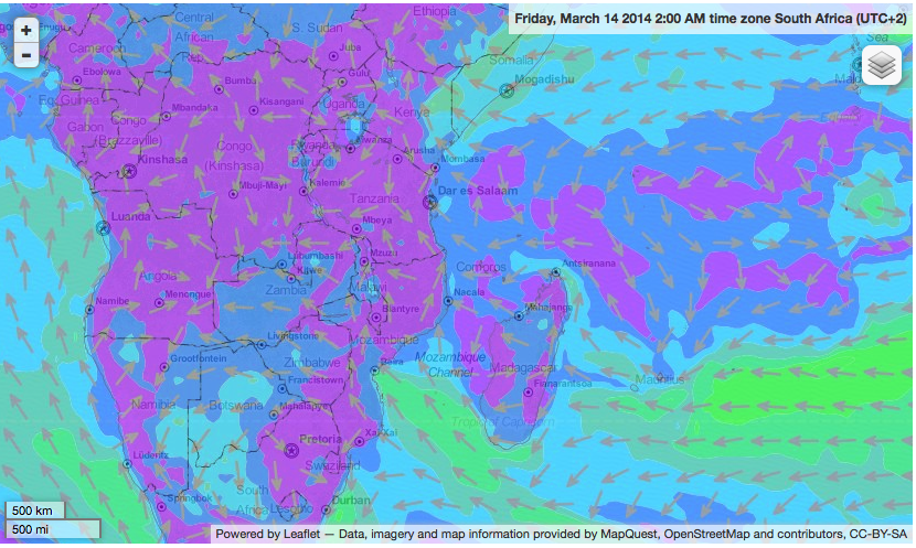
Over the continent of Africa, there is a low pressure system forming in the Northwestern region, though there aren't very many low pressure readings on the surface analysis map. There are two high pressure systems affecting Africa, one directly north of the continent, and the other on the southern border of the continent. Both high pressure systems have a center pressure reading of 1020 mb, with readings of 1016 mb, 1012 mb, and 1008 mb all spaced far apart. This signifies a low pressure gradient over a large distance, which means the wind isn't very strong in the entire region. The only front close to the African continent is a stationary front off the southeastern coast of Africa. 


Thursday, March 13, 2014

Global and Local Winds in Zimbabwe

Zimbabwe is a African country at coordinates 19.0167 degrees south latitude, 30.0167 degrees east longitude. This puts Zimbabwe in the Southern Hemisphere, well within the tropics (from 23.5 degrees south to 23.5 degrees north latitude). According to the three cell model of global circulation discussed in lecture, Zimbabwe lies within the Hadley cell of atmospheric circulation (from 0-30 degrees north or south latitude). The Hadley cell consists of rising warm air at the equator cooling and moving towards 30 degrees N or S latitude where the air sinks and moves back towards the equator. The pressure gradient force is towards the equator from the location of the sinking air at 30 degrees S. In the southern hemisphere, the Coriolis Effect curves wind to the left, and friction in the opposite direction of the PGR curves the wind back towards the PGF. This explains the direction of the trade winds, which is the wind belt that Zimbabwe resides in. Though the trades blow east to west, the prevailing wind direction in Zimbabwe is hardly defined due to the location of Madagascar off the coast of Eastern Africa and how drastically it influences wind direction. Zimbabwe is located in the ITCZ, or Intertropical Convergence Zone, which is a main low pressure system that varies in latitude depending on the time of year. January is when Zimbabwe lies within the ITCZ, and is subsequently right in the middle of Zimbabwe's rainy season. Because Zimbabwe is within the ITCZ in January, it is also within the doldrums during this time. Doldrums are where the northern and southern trade winds meet at the equator  and creates an area of highly variable weather.

image from http://www.weatherwizkids.com/globalcirculation.gif

Zimbabwe's climate is directly affected by global wind patterns and pressure systems relevant to it's location. Zimbabwe's location at 19 degrees S puts it in the Hadley cell, which means wind is generally moving from east to west. This means that future weather can be predicted by looking at what type of pressure systems are developing over the Indian Ocean being that the wind is most likely going to blow this weather westward. Also Zimbabwe is very characteristic of tropical countries in that it has a distinct wet and dry seasons. This is due to the ITCZ shifting throughout the year and in January is when Zimbabwe lies within the ITCZ. In past years when the ITCZ wasn't very well defined, Zimbabwe experienced drought-like climate, and in past years when the ITCZ was very well defined, Zimbabwe receives average to higher than average rainfall. The rainy season occurs when the ITCZ approaches and reaches Zimbabwe, and the rest of the year receives essentially zero rainfall. This makes it easy to predict the weather of Zimbabwe during any time of the year.

Zimbabwe has many mountains, from the Bvumba Mountains to the Eastern Highlands. The 5 types of breezes associated with mountains is the Chinook Winds, Santa Ana Winds, Katabatic Winds, Valley breezes and mountain breezes. Most of Zimbabwe's higher-elevation terrain is located on the eastern side of the country, though it has a minor effect of the wind direction because of the location of Madagascar, and how Madagascar actually is the main contributor to the unique winds in Zimbabwe. Because the trade winds blow from east to west and Madagascar lies east of Zimbabwe, the trade winds' path is blocked and deviated around the island, resulting in a northwestern prevailing wind direction. Madagascar also acts as a barrier to severe weather systems heading directly towards Mainland Africa, weakening and deviating it's path which lowers the instances of weather related disasters.

image from http://www.windfinder.com/weather-maps/forecast/zimbabwe#4/-12.38/41.31

Because Zimbabwe is landlocked, it is not directly affected by coastline breezes, such as land and sea breezes. The closest body of water is the Mozambique Channel, almost 500 miles away.